Physical Address
304 North Cardinal St.
Dorchester Center, MA 02124
Physical Address
304 North Cardinal St.
Dorchester Center, MA 02124
Your guide to extraordinary adventures around the globe.
Your guide to extraordinary adventures around the globe.
Distance: 160–230 km | Duration: 11–20 days | Highest point: Thorong La Pass, 5,416m | Difficulty: Moderate to Challenging
I am, by instinct, a planner. The kind of traveler who reads weather forecasts for places they haven’t booked yet. Who cross-references three different trail maps before lacing up their boots. So when I decided to trek the Annapurna Circuit — one of the most storied long-distance routes in the Himalayas — I naturally went looking for the one guide that would tell me everything I actually needed to know. I didn’t find it. So here it is.
This is the complete guide to the Annapurna Circuit Trek: what the trail actually looks like on your legs, your lungs, and your schedule. What the science of altitude sickness tells you to do — and what most trekkers ignore. What you genuinely need to pack versus what you can rent for $2 a day in Kathmandu. And how to give yourself the best possible chance of standing on Thorong La Pass at sunrise, looking out over the Annapurna and Dhaulagiri ranges, wondering why you ever worried at all.
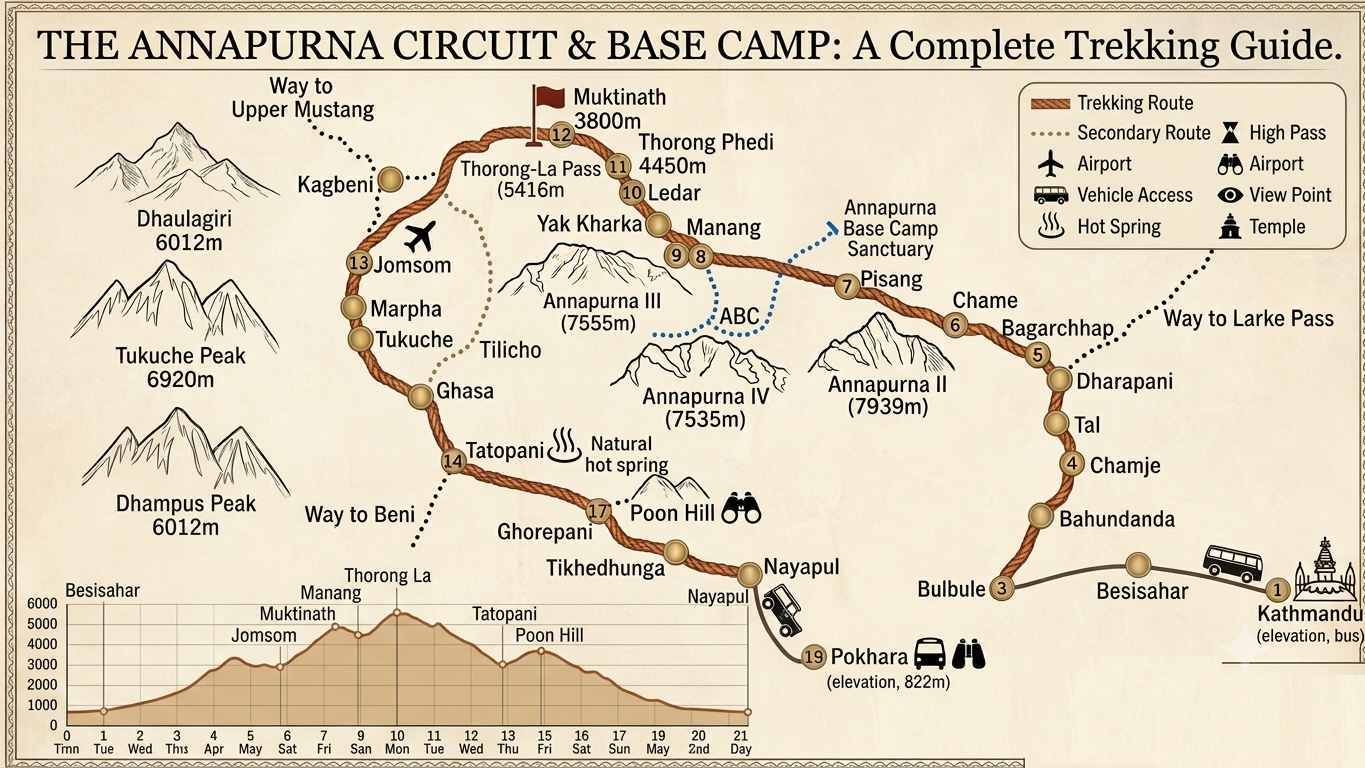
The Annapurna Circuit is a circumnavigation of the entire Annapurna Massif in central Nepal. The trail stretches between 160 and 230 kilometres depending on your route, carrying you through subtropical river valleys, medieval Gurung villages, alpine meadows, high-altitude desert, and finally over Thorong La Pass at 5,416 metres, one of the highest trekking passes in the world.
It’s been drawing trekkers since the 1970s. It remains, for good reason, one of the most popular long-distance treks on earth. The variety alone is extraordinary: within two weeks you’ll walk through terraced rice fields, pine forests smelling of resin, and barren moonscapes that look borrowed from the Tibetan plateau. You’ll sleep in teahouses where the dal bhat arrives steaming and unlimited, and wake up to views of peaks most climbers spend years trying to summit.
The catch- and there is one- is altitude. The trek’s highest point demands respect. More on that shortly.
The honest answer is: longer than you think, and not as long as you fear.
The classic full circuit takes 15–20 days at a comfortable pace. This includes an acclimatization rest day in Manang (non-negotiable, not optional) and gives your body time to adjust gradually rather than forcing the issue.
If you’re pressed for time, a 10–14 day itinerary is possible by starting your trek from Chame or Chyamche rather than Besisahar, and taking a jeep or flight from Jomsom back to Pokhara. The trade-off is skipping the lush lower valleys — including Tal village and the Octopus Waterfall — which shorter itineraries tend to bypass entirely.
Some agencies advertise an 8-day circuit. Avoid it. Compressing the ascent that aggressively removes your margin for acclimatization. The mountain doesn’t care about your return flight.
The classic Annapurna Circuit follows this arc:
Kathmandu → Besisahar/Jagat (Drive) Most modern itineraries drive from Kathmandu to Jagat or even Chyamche, bypassing the first section of trail that now runs alongside a road. The trek proper begins here, following the Marsyangdi River northward.
Jagat → Dharapani → Chame (Days 1–3) The trail enters dense pine, fir, oak, and maple forest. The Marsyangdi roars alongside you. Villages appear like interruptions — Dharapani at 1,860m, Koto at the permit checkpoint, Chame at 2,670m — and the Annapurna massif begins to show its shape above the treeline.
Chame → Pisang → Manang (Days 4–5) This is where the landscape pivots. Above Chame the forest thins and the terrain opens into something wilder. The views of Annapurna II and Annapurna IV announce themselves properly. Upper Pisang, at 3,300m, offers the first real Himalayan panorama of the trip. By the time you reach Manang at 3,540m, the air feels noticeably different.
Manang: Acclimatization Day (Day 6) Do not skip this. The medically recommended approach to high altitude is to ascend gradually and build in rest days above 3,000m. A passive rest day, however, is less effective than an active one. Hiking to Gangapurna Lake or Kicho Ice Lake — both above Manang — trains your cardiovascular system for the demands ahead without the sustained exertion of a full trek day.
Manang → Yak Kharka → Thorong Phedi (Days 7–8) The trail climbs into yak country. Settlements become sparse. The teahouses at Thorong Phedi at 4,540m are the last stop before the pass, and most trekkers are in bed by 8pm, setting an alarm for 4am.
Thorong La Pass: Crossing Day (Day 9) Start before dawn. The standard advice is to reach Thorong La Pass before 10am — afternoon winds on the pass are strong enough to cause serious trouble, and the descent to Muktinath is long. The ascent from Thorong High Camp to the pass takes four to six hours. The terrain is a mix of rocky switchbacks and, depending on the season, ice and snow. Every trekker stops every ten to fifteen minutes to breathe. This is normal. The summit cairns and prayer flags at 5,416m are, in every meaningful sense, worth it.
Muktinath → Jomsom → Pokhara (Days 10–11) The descent to Muktinath, a sacred site for both Hindus and Buddhists, is steep and knee-testing. From Jomsom — a dusty, wind-blasted town famous for its apple orchards — most trekkers fly or drive to Pokhara, the lakeside city where every trek in the Annapurna region seems to begin and end.
The Annapurna Circuit is rated moderate to challenging, which is a category that covers considerable ground. Here’s what that means in practice.
You don’t need technical climbing skills. There are no ropes, no crampons required for most of the route (though microspikes are advisable for Thorong La from October onwards). What you do need is cardiovascular fitness, a tolerance for sustained uphill effort across multiple consecutive days, and the psychological steadiness to manage altitude symptoms without panicking.
The most common reason trekkers turn back is not exhaustion — it’s altitude sickness. Acute Mountain Sickness typically begins above 3,000m. Symptoms include persistent headache, nausea, loss of appetite, confusion, and a dry cough. The treatment for mild AMS is straightforward: stop ascending, rest, hydrate, and descend if symptoms worsen. Acetazolamide (Diamox) is commonly used as a preventive measure, but only after consultation with a physician before departure.
The section between Yak Kharka and Thorong Phedi passes through an active landslide zone. Start early in the morning when rocks are cold; afternoon sun heats the slope and raises rockfall risk.
The rest of the trail? Honest hard work, but well within reach for any reasonably fit person who’s prepared.
The question most people ask is “am I fit enough?” The better question is “am I fit enough yet, and what do I do between now and departure?”
For trekkers who are currently sedentary or only occasionally active, 12 weeks of dedicated preparation makes a measurable difference:
Trekkers who already hike monthly, cycle, or play recreational sport twice a week can compress this into 6–8 weeks of supplementary training.
Permit requirements for the Annapurna region have changed in recent years. Here’s the current picture:
ACAP (Annapurna Conservation Area Permit): NPR 3,000 (approximately USD 22). This is the mandatory permit for the Annapurna Circuit. It funds trail maintenance and conservation across the region. Purchase it at the Nepal Tourism Board office in Kathmandu’s Thamel district or at NTNC offices in Pokhara’s Lakeside area.
TIMS Card: NPR 2,000 for trekkers using a registered agency. Some recent sources indicate the TIMS card is no longer strictly enforced for the standard Annapurna Circuit. Verify current requirements before departure, as regulations change.
Mandatory Guide Rule (2025 onwards): Nepal’s government made licensed guides mandatory for the Annapurna Circuit effective 2025. Solo trekkers without a guide are in violation of current regulations. Trekking with a licensed agency qualifies you for the lower TIMS rate and simplifies the permit process considerably.
Restricted Area Permits: Not required for the standard Annapurna Circuit route. Required only for side extensions including Upper Mustang, Nar Phu Valley, or Kang La Pass.
The Annapurna Circuit takes you through five climate zones. Underpacking above 4,000m creates genuine danger. Overpacking creates fatigue on every ascent below it. Target pack weight: main pack 10–12kg (carried by porter), daypack 4–5kg (carried by you).
Footwear:
Clothing:
Gear:
What to rent in Kathmandu or Pokhara: Down jacket, sleeping bag, microspikes, and trekking poles are all rentable for USD 1–3 per day. There is no compelling reason to buy these items if this is your only Himalayan trek.
The Annapurna Circuit crosses a high pass and passes through a monsoon-affected region, which means your timing window matters more than on lower-altitude routes.
Autumn (September–November): The best season for most trekkers. The monsoon has cleared, skies are stable, visibility is exceptional, and Thorong La Pass remains reliably open. October is peak season — book teahouses in Manang and Thorong High Camp at least two weeks in advance.
Spring (March–May): The second-best window. Rhododendrons bloom in the lower valleys, days are long, and mountain views are clear. Weather is slightly less stable than autumn, with more afternoon cloud buildup.
Winter (December–February): Possible in recent years as milder temperatures have made the trek more feasible, but Thorong La carries real avalanche and snowpack risk. Only for experienced winter trekkers with appropriate equipment.
Monsoon (June–August): The least favorable season. Trails become slippery and leech-ridden in the lower sections, and Thorong La can be impassable. Not recommended.
Package prices from reputable agencies start at around USD 950 per person for a 15-day guided trek, typically including a licensed guide, teahouse accommodation, trail meals, permits, and airport transfers. More comprehensive packages with private jeep transfers and acclimatization extensions reach USD 1,300–1,500.
Independent trekking costs vary but budget for:
From 2025, the Nepalese government requires all solo trekkers on the Annapurna Circuit to hire a licensed guide. The decision is therefore less “guide or no guide?” and more “which guiding arrangement suits me?”
Independent-minded trekkers can still control their own pace and itinerary while hiring a guide directly in Besisahar or Kathmandu. Guides provide genuine value beyond navigation: they monitor your acclimatization, communicate with teahouses in Nepali, manage emergencies with local knowledge, and offer cultural context that transforms anonymous landscapes into inhabited places.
Group trekkers who want company, organised logistics, and the social dimension of sharing the experience should consider a guided group package. Most operators offer departure guarantees on fixed dates through peak season.
Altitude sickness is the Annapurna Circuit’s most serious risk, and it’s also the risk most frequently underestimated by first-time high-altitude trekkers who feel fine at sea level.
Acute Mountain Sickness (AMS) occurs when you ascend faster than your body can adapt to reduced oxygen pressure. It’s not a fitness issue — elite athletes get AMS. It’s a physiology issue that proper pacing manages effectively.
The established guidelines are clear: ascend no more than 300–500 metres of sleeping altitude per day above 3,000m, and include a rest day for every 1,000 metres gained. The mandatory acclimatization day in Manang before the Thorong La attempt is not the agency being cautious — it is clinically sound advice. Use it actively, not passively: a hike to 4,000m and back trains your red blood cell response better than a day in bed.
Symptoms to take seriously: a headache that doesn’t respond to hydration and ibuprofen, vomiting, loss of coordination, or any confusion. Descend immediately. Do not sleep at altitude with worsening symptoms.
The Annapurna Circuit is a destination in itself, but the region rewards trekkers who build in time for extensions.
Tilicho Lake (add 2–3 days): A detour from Khangsar village near Manang to one of the highest lakes in the world at 4,919m. Stunning, and not overcrowded relative to the main circuit.
Ice Lake (Kicho Tal): A half-day hike above Manang to 4,600m. Typically done on acclimatization day, it’s one of the more rewarding high-altitude viewpoints on the entire trek.
Poon Hill extension (add 4 days): For trekkers who want to extend the circuit through Ghorepani and the famous Poon Hill sunrise viewpoint at 3,210m, the classic Ghorepani-Poon Hill loop adds four days and is one of the most photographed sunrise perspectives in Nepal.
The teahouse system on the Annapurna Circuit is, genuinely, more impressive than it has any right to be. At elevations where every piece of furniture was carried in on someone’s back, you’ll find clean rooms, hot meals, charging points, and intermittent WiFi.
A typical Nepali teahouse meal — dal bhat (rice, lentil soup, curry, and pickle) — is the most reliable option on trail and usually comes with unlimited refills. It is vegan by default and extraordinarily well-suited to the caloric demands of a full trekking day.
Higher elevations charge more for rooms, hot showers, and electricity. Budget accordingly: what costs NPR 500 in Chame costs NPR 1,000 in Manang and NPR 1,500 at Thorong Phedi.
A few things that guidebooks mention only in passing:
Your feet will hurt more than your lungs. The descent from Thorong La to Muktinath is steep and long and relentless on the knees. Trekking poles and well-fitted boots prevent a miserable afternoon.
Thorong La at 5,416m is brutal and beautiful in equal measure. The wind at the pass is cold enough to cut through a down jacket if you stop moving. The prayer flags snap like rifle shots. The views extend to ranges you won’t be able to name and won’t forget.
Manang is the social heart of the trek. Something about the acclimatization day and the altitude makes strangers generous with conversation. The tea shops fill up with trekkers comparing blister treatments and swapping itinerary advice with the seriousness of generals planning a campaign.
The second half of the circuit is genuinely different terrain. After Muktinath, the landscape flattens and the road reappears. Many trekkers find the first half — from Besisahar to Thorong La — the emotional core of the journey, and take a jeep or flight from Jomsom rather than walking the lower Mustang section.
And one thing worth saying plainly: the Annapurna Circuit is not a casual undertaking. But it is an achievable one. Thousands of first-time Himalayan trekkers complete it every year. The ones who turn back mostly did so because they moved too fast and ignored what their body was telling them. The mountain is patient. The itinerary can flex. The pass will be there tomorrow.
| Distance | 160–230 km |
| Duration | 11–20 days |
| Highest Point | Thorong La Pass, 5,416m |
| Difficulty | Moderate to Challenging |
| Best Season | October–November (Autumn), March–May (Spring) |
| Permits Required | ACAP (NPR 3,000), TIMS Card (NPR 2,000–4,000) |
| Guide Requirement | Mandatory for solo trekkers (from 2025) |
| Package Cost | From USD 950 per person (guided, 15 days) |
| Starting Point | Besisahar or Chame (Kathmandu drive) |
| Finishing Point | Pokhara (via Jomsom) |
Planning the Annapurna Circuit? The preparation investment pays off every single day on the trail. Start your fitness training twelve weeks out, sort permits before you fly, and build in one more rest day than you think you need. The mountains will meet you halfway.