Physical Address
304 North Cardinal St.
Dorchester Center, MA 02124
Physical Address
304 North Cardinal St.
Dorchester Center, MA 02124
Your guide to extraordinary adventures around the globe.
Your guide to extraordinary adventures around the globe.

Distance: ~130 km round trip | Duration: 12–16 days | Highest point: Kala Patthar, 5,545m | Difficulty: Moderate to Challenging
There’s a particular kind of person who decides to trek to Everest Base Camp. They’re not, on the whole, mountaineers. They haven’t rappelled anything. Their most recent physical challenge was probably a flight of stairs with heavy luggage and an uncooperative trolley. And yet here they are — searching “Everest Base Camp trek guide” at midnight, adding crampons to wishlists, wondering what a Sherpa actually does.
I know this person. I am this person.
What I needed, before I went, wasn’t another agency itinerary dressed up as editorial content. What I needed was a guide written by someone who had genuinely sat with altitude headaches in Namche Bazaar at 3,440 metres, genuinely woken up at 3am in Gorak Shep to face the Kala Patthar climb, and genuinely stood at Everest Base Camp wondering whether the tears were from the altitude or the achievement. Probably both, it turns out.
This is that guide. Everything you actually need- the route, the science, the costs, the packing reality, the altitude facts the agencies mention in a bullet point and then immediately move on from- in one place, written straight.
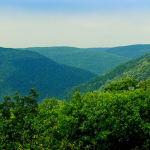
The Everest Base Camp Trek is a high-altitude walking route through Nepal’s Khumbu Valley to the southern base camp of Mount Everest, at 5,364 metres above sea level. Most trekkers also climb Kala Patthar, a peak at 5,545m with an unobstructed view of Everest’s summit- which has become, for practical purposes, the emotional and photographic high point of the entire journey.
The trail covers roughly 130 kilometres from Lukla to base camp and back. You don’t summit anything. You don’t use ropes or ice axes. What you do, over 12 to 16 days, is walk deeper into the Khumbu than most people on earth will ever go through rhododendron forests and glacial moraines, through Sherpa villages where Buddhism isn’t a lifestyle aesthetic but a daily practice, past memorials to climbers who didn’t come back from the mountain above you.
The trek has been drawing visitors since the 1970s. It remains, for good reason, the most famous trek in the world. The question isn’t whether it’s worth doing. The question is whether you’re ready to do it properly.
The honest answer: longer than most agencies’ headline numbers suggest, and for good reason.
The standard itinerary runs 14 days from Kathmandu — including the Lukla flight, two mandatory acclimatization days (Namche Bazaar and Dingboche), EBC itself, the Kala Patthar sunrise climb, and the return to Lukla. This is not conservative padding. This is the medically sound pace for a route that asks you to sleep above 5,000 metres.
12-day itineraries exist. They compress the acclimatization days and assume nothing goes wrong: no headache that won’t shift, no Lukla flight delay, no morning when your legs simply refuse to engage. They work for some people. They’re an unnecessary gamble for most.
16-day versions build in buffer days for Lukla weather delays (which are routine, not exceptional) and side trips to Gokyo Lakes or Island Peak base camp. For first-time Himalayan trekkers, the extra days are genuinely worth the cost.
A note on Lukla flight delays: the airstrip at Lukla is one of the most dramatic in the world, perched on a mountainside at 2,860 metres. It operates on visual flight rules, which means cloud, fog, or high winds ground all flights. Budget for at least one day’s delay in each direction. It is not a matter of if; it is a matter of when.
The classic EBC route is an out-and-back trail from Lukla through the Khumbu Valley. You arrive the same way you leave, which means the familiar landmarks on the descent carry a different weight — you’re recognising them now, rather than encountering them.
Lukla to Phakding (Day 1) The Lukla flight from Kathmandu takes 35 minutes and ends with a landing that feels, to every first-timer, statistically improbable. The plane banks sharply into the valley, the airstrip rises steeply in front of you, and then you’re there: Lukla, 2,860 metres, prayer flags snapping in the wind, the whole Khumbu laid out ahead. The walk to Phakding is a gentle 3 hours — a deliberate easing-in, the trail descending through pine forests and small villages along the Dudh Koshi River.
Phakding to Namche Bazaar (Day 2) The day that sorts out how your knees feel about this plan. The trail crosses a series of high suspension bridges — the Hillary Suspension Bridge, hung with prayer flags, is the most photographed — and then climbs steeply for the final two hours to Namche at 3,440 metres. If your body is going to register the altitude, it usually announces itself here: a dull pressure behind the eyes, a slight reluctance to hurry. This is normal. Sit with it.
Namche Bazaar: Acclimatization Day (Day 3) Namche is the Khumbu’s improbable capital — a horseshoe of lodges, bakeries, gear shops, and expedition outfitters carved into a steep hillside. On your acclimatization day, the protocol is an active hike to a higher elevation followed by a descent back to sleep at Namche. The Hotel Everest View at 3,880 metres is the standard objective — a 90-minute climb with a first proper sighting of Everest, Lhotse, and Ama Dablam from the terrace — followed by a leisurely descent. Your body learns more from this than from a day in bed.
Namche to Tengboche (Day 4) The trail above Namche reveals what the previous two days have been building toward: Ama Dablam, the mountain most trekkers agree is the most beautiful in the Himalayas, appears above the valley and stays visible for most of the day. Tengboche Monastery at 3,855 metres is one of the highest monasteries in the world. The puja ceremony at dusk, if you’re there for it, is unhurried and hypnotic.
Tengboche to Dingboche (Day 5) The landscape changes register above Tengboche. The trees thin and eventually disappear. The trail enters an open, rocky valley with unimpeded views in every direction — Everest, Nuptse, Lhotse, Makalu forming a skyline that stops you mid-step more than once. Dingboche sits at 4,410 metres at the junction of two valleys; the altitude is palpable now in a way that’s neither alarming nor comfortable.
Dingboche: Acclimatization Day (Day 6) The second mandatory rest day, typically used for a hike to Nagarjun Hill (5,100m) or the ridge above Dingboche for views of Island Peak and Makalu. Same protocol as Namche: climb high, sleep low. The logic holds at every elevation: altitude adaptation is triggered by exposure, consolidated by rest at the lower sleeping altitude.
Dingboche to Lobuche (Day 7) A walk through increasingly lunar terrain to Lobuche at 4,940 metres. The memorial chortens on the ridge before Lobuche are sobering — cairns and plaques for climbers and Sherpas who died on Everest and the surrounding peaks. The mountain above is not an abstraction here.
Lobuche to Gorak Shep and Everest Base Camp (Day 8) The longest and most demanding day of the trek. The trail to Gorak Shep at 5,164 metres crosses the Khumbu Glacier’s lateral moraine — rubble and ice that requires attention on every step. From Gorak Shep, you drop your main pack and continue to Everest Base Camp at 5,364 metres: another 3 hours across the glacier, the route marked with cairns and, during climbing season, the orange and yellow dots of expedition tents.
Base camp is not a viewpoint. Everest’s summit is hidden from here, tucked behind the Khumbu Icefall. What you see is the glacier, the icefall, the surrounding peaks, and the camp itself — a sprawling, semi-permanent city of tents in April and May, a quiet moraine in other seasons. What you feel is harder to describe and easier to trust than any description.
Gorak Shep to Kala Patthar (Day 9) The 3am alarm is not optional. The climb from Gorak Shep to Kala Patthar at 5,545 metres takes 1.5 to 2 hours in the dark, a headlamp picking out the rocky trail while the temperature drops well below zero. You arrive at the summit in time for a sunrise that turns Everest’s south face from grey to amber to white while you stand there, breathing hard, wondering how anything gets to be this beautiful. Descend to Gorak Shep for breakfast, then continue down toward Pheriche or Dingboche.
Return: Days 10–12 The descent back to Lukla covers the same trail in reverse, noticeably faster and easier than the climb. Most trekkers are back in Lukla by Day 12, with Day 13 for the return flight to Kathmandu.
The standard categorisation — moderate to challenging — is accurate but unhelpfully broad. Here’s what the trail actually demands.
Physically: You’ll walk five to seven hours daily, often on uneven rocky terrain, at elevations where the air contains 40–50% less oxygen than at sea level. The daily distances are not extreme — 10 to 15 kilometres — but the altitude slows everything. What would take two hours at sea level takes three above 4,000 metres. Factor that into every expectation you hold about your own pace.
The altitude: This is the variable no fitness level can shortcut. Acute Mountain Sickness (AMS) is not a fitness failure — it’s a physiological response to reduced oxygen pressure that can affect elite athletes and beginners alike. The most common symptoms above 3,000 metres are persistent headache, nausea, fatigue, and disturbed sleep. The treatment for mild AMS is to stop ascending and rest. If symptoms worsen after 24 hours — particularly any loss of coordination, confusion, or a cough that sounds wet — descend immediately. These are symptoms of High Altitude Cerebral Edema (HACE) or High Altitude Pulmonary Edema (HAPE), both of which are life-threatening if not treated by descent.
The most important sentence in this guide is the one trekking agencies mention and then quickly move past: never ascend with symptoms. The Khumbu Valley is full of trekkers who think they can push through a headache to the next teahouse. Some of them turn out to be right. Some of them end up in a helicopter.
Technically: Zero technical climbing skills required. The trail is well-marked and well-worn. A licensed guide is now mandatory for the Everest region.
The question most people ask is “am I fit enough?” The better question is “am I fit enough yet, and what do I need to do about it?”
For a person who currently walks occasionally and does no regular cardio training, a 16-week preparation window is appropriate:
Weeks 1–4: Daily 45-minute walks. Focus on consistency rather than intensity. The goal is to make sustained walking a habit your body expects.
Weeks 5–10: Introduce stair climbing and hill walking with a loaded pack. Begin at 5kg, increase to 8kg by week ten. Aim for three to four sessions per week including one longer weekend hike of 3–4 hours.
Weeks 11–16: Two consecutive-day long hikes (Saturday and Sunday) of 4–6 hours each. Simulate the repetitive daily effort of the trail. Add elevation wherever your geography allows.
For trekkers who already hike monthly or do regular cardio: an 8-week targeted plan with weekly back-to-back long hikes and loaded pack training is sufficient.
One thing no training plan can simulate is altitude. Your body’s acclimatization response is largely genetic and cannot be trained at sea level. What training provides is the cardiovascular base to handle the effort at altitude — crucial, but different from altitude adaptation itself.
Sagarmatha National Park Entry Permit: NPR 3,000 (approximately USD 22). Sagarmatha is a UNESCO World Heritage Site. The permit is issued at the national park entrance gate at Monjo, roughly a day’s walk from Namche.
TIMS Card (Trekkers’ Information Management System): NPR 2,000 for agency trekkers; NPR 4,000 for independent trekkers. Required for all trekkers in the region.
Khumbu Pasang Lhamu Rural Municipality Entry Permit: NPR 2,000. A local government permit introduced in recent years, checked at Lukla.
Mandatory Guide: As of current regulations, a licensed guide is compulsory for the Everest region. Independent trekking without a guide is not permitted. Reputable agencies include the guide cost in their package fee; independent trekkers hiring directly in Kathmandu should expect to pay USD 35–45 per day for a licensed guide.
Total permit cost: approximately USD 50–60 at current rates, not including guide fees.
Standard guided package prices from reputable agencies run between USD 1,300 and USD 2,200 per person for a 14-day trek, typically including a licensed guide, teahouse accommodation, trail meals (breakfast and dinner), permits, Lukla flights, and Kathmandu hotel. The range reflects group size, accommodation standard, and operator quality.
For budget-conscious independent trekkers hiring guide and porter directly:
Travel insurance is not optional. A helicopter evacuation from the Khumbu to Kathmandu costs USD 4,000–6,000 without coverage. Ensure your policy explicitly covers emergency evacuation above 5,000 metres.
Autumn (September–November): The best all-round season. Post-monsoon skies are clear, visibility is exceptional, and the trail conditions are excellent. October is peak season and peak crowd — teahouses in Namche and Dingboche fill early. Book two to three weeks in advance for October departures.
Spring (March–May): The second window. Rhododendron forests bloom in the lower valleys, temperatures are warming, and the trail is active with Everest climbing expeditions. April brings the most dramatic base camp atmosphere — expedition tents, high-altitude porters, the particular energy of a summit attempt in preparation. May can be unstable as the pre-monsoon weather builds.
Winter (December–February): Possible for experienced cold-weather trekkers, but temperatures at altitude drop to -20°C and below. Teahouses remain open but thin on other trekkers. Kala Patthar in winter requires proper layering and cold-weather experience.
Monsoon (June–August): Not recommended. Trails become slippery, leeches populate the lower sections, and mountain views are largely obscured. Some trekkers go; most who do wish they’d waited.
The teahouse system in the Khumbu is one of the genuine wonders of the trekking world. Family-run lodges at elevations that would seem to defy hospitality offer clean rooms, hot meals, and a kind of sociability that makes the trail feel less solitary than the altitude might otherwise suggest.
The standard teahouse room is simple — two wooden beds, foam mattresses, blankets, and a window. At lower elevations this costs NPR 500–800 per night; above 4,000m, room prices often become nominal because the economics of teahouse business depend on meal revenue. Eat where you sleep. It’s the unspoken social contract of the trail, and it’s a reasonable one.
Dal bhat — rice, lentil soup, vegetable curry, pickle — is the meal the Khumbu runs on. It arrives hot, it refills without asking, and it is almost perfectly calibrated to the caloric demands of a long trekking day. At altitude, appetite diminishes. Eat anyway.
Hot showers cost NPR 300–500 extra. WiFi costs NPR 300–600 per hour or per session, and speeds become increasingly philosophical above Namche. Device charging runs NPR 200–500 per device. Budget for all of these separately; they add up across a fortnight.
The general principle: your porter carries your main pack (8–10kg maximum, non-negotiable for their welfare as much as yours); you carry a daypack of 4–5kg with essentials for the walking day.
Footwear:
Clothing system (layers are everything):
Gear:
What to rent or buy in Kathmandu: Down jacket, sleeping bag (rated to -10°C minimum), trekking poles, microspikes or gaiters. Thamel in Kathmandu has excellent rental infrastructure at USD 1–3 per day for quality gear.
Here’s the thing most guides gloss over: from Everest Base Camp itself, you cannot see the summit of Everest. The mountain is hidden behind the West Ridge and the Khumbu Icefall. What you see at base camp is the icefall, the surrounding peaks, and the camp itself.
From Kala Patthar at 5,545m — 181m higher than EBC — you see the full south face of Everest clearly, including the summit pyramid and the Hillary Step. This is why every photograph described as “view of Everest from base camp” is almost certainly taken from Kala Patthar.
The standard itinerary includes both, and there’s no sensible reason to skip either. But if you’re wondering which one delivers the view — it’s Kala Patthar. EBC delivers something harder to photograph: the feeling of standing at the foot of the highest point on earth, in a place that is not accessible to most of humanity, having walked there on your own legs.
A few things that earn brief mentions in most guides and deserve more:
The Lukla flight is legitimately exciting. This is not a routine domestic hop. The cockpit view during approach is extraordinary, the passengers are almost universally trekkers in various states of pre-trek anxiety, and the landing — on a 460-metre uphill runway at 2,860m — is something you will describe to other people for years.
The Khumbu Glacier moraine section is harder than people say. The terrain between Lobuche and Gorak Shep is loose rock and boulder-hopping across an active glacier system. At 5,000 metres, with reduced coordination from altitude, this section demands full attention. Take your time. This is not the place to rush.
The descent feels like a different trek entirely. Going down takes two to three days less than going up. The trail looks different, the light is different, and you are different — you know what’s around each bend now, and you carry the memory of where you’ve been. Several trekkers have told me the descent is when they actually process the achievement. The ascent is too consumed by what’s ahead.
The memorial chortens above Lobuche will stop you. The cairns and plaques for climbers killed on Everest and the surrounding peaks are not a footnote — they’re a full stop in the middle of the journey. The mountain has claimed a sobering number of people. Standing there, knowing what’s above, the experience of the trek shifts from adventure to something more complicated and more honest.
| Distance | ~130 km round trip (Lukla–EBC–Lukla) |
| Duration | 12–16 days |
| Highest point trekked | Kala Patthar, 5,545m |
| EBC altitude | 5,364m |
| Difficulty | Moderate to Challenging |
| Best seasons | Oct–Nov (Autumn), Mar–May (Spring) |
| Permits required | Sagarmatha NP permit + TIMS + Municipality permit |
| Guide requirement | Mandatory (from 2025) |
| Package cost | USD 1,300–2,200 per person (14 days, guided) |
| Starting point | Lukla (fly from Kathmandu, 35 min) |
| Key acclimatisation stops | Namche Bazaar (Day 3), Dingboche (Day 6) |
The question that splits every trekking group that ever convened in a Thamel guesthouse.
The Everest Base Camp Trek is a focused journey- a single valley, a single destination, a singular pull toward the world’s highest mountain. The trail is more heavily used, the teahouses more developed, the experience more defined. You know exactly what you’re going toward.
The Annapurna Circuit is a circumnavigation- a loop, a broader landscape, five distinct climate zones and dozens of villages across a route that changes character every two days. More varied, less iconic, equally extraordinary.
If you want to stand at the foot of Everest, take the EBC trek. If you want the richer and more varied route through the Himalayas, do the Annapurna Circuit. If you have the time and the knees for both — do both.
The mountain, famously, does not care whether you’re ready. Fortunately, the guide is there for exactly that reason. Book early, train properly, and give yourself one more acclimatization day than you think you need. The rest takes care of itself.